
S
P
O
I
L
E
R
S
P
A
C
E
Last week I gave you an 18×17 grid with only one obvious theme entry, INTERSTATE HIGHWAYS running across the center. With the instructions referencing road trips in unfamiliar territory, surely that was important … now what? Well, you may have also noticed the grid was very heavy on four-letter entries, and that turned out to be no accident. Several of these (ten, matching the number of letters the meta prompt says is in the solution) consisted of the postal codes for adjacent states, highlighted in blue and green below:
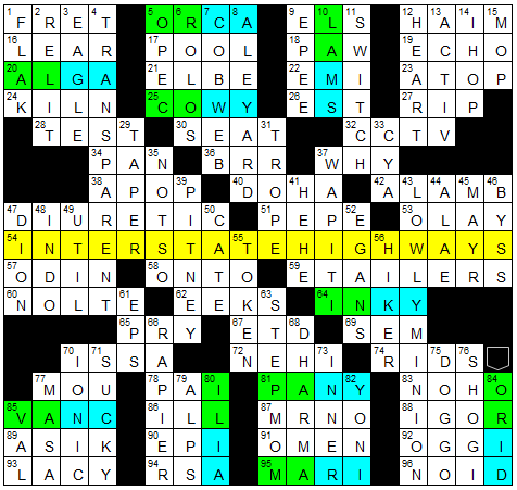
The key here was that one can travel between each pair of states on an interstate highway – and not just any interstate highway, but the one whose number matches the entry. That is, you can take Interstate 5 from Oregon to California, corresponding with 5-across ORCA. And so on.
Next, with a nudge from the puzzle title, solvers were to give me directions, specifically the direction of travel from the first state to the second, along the specified Interstate, as designated for that highway (so, north/south for odd-numbered highways, east/west for even). Like this:
- To get from OR to CA, take I-5 S
- To get from LA to MS, take I-10 E
- To get from AL to GA, take I-20 E
- To get from CO to WY, take I-25 N
- To get from IN to KY, take I-64 E
- To get from IL to IA, take I-80 W
- To get from PA to NY, take I-81 N
- To get from OR to ID, take I-84 E
- To get from VA to NC, take I-85 S
- To get from MA to RI, take I-95 S
… spelling out our contest answer, the (stilted, as indicated) phrase “SEE NEWNESS.”
A vague notion of this puzzle came to me late one night – I think it started with the observation that ORCA is a word made from the abbreviations for consecutive states, and the idea that you could stick that at 5-across or 5-down to correspond to the interstate number, and then the question “could I find more such pairs?” I’m not entirely sure when or how the “extract the direction of travel” idea came about. Anyway, after a hunt through the Wikipedia pages for damn near every Interstate in America, I had my list of ten border crossings on ten distinct highways, in numerical order, the directions spelling out this odd phrase that I could make thematic … and then I started trying to make the grid, and it took days. Every time I thought I had it, something would have shifted by one clue number and wrecked it. Finally, with the help of some cheater squares making those weird black areas on the sides, I had it, and I filled the grid and was feeling very satisfied … until I did a final check for accuracy and realized I had blown it, thinking the Illinois/Iowa crossing was on I-70, not I-80! I was about to start tearing hair out when I realized that somehow, miraculously, fixing it wouldn’t change the order of the theme entries – I hadn’t found any good candidates in the 70s – nor did I have to alter my grid – 80-down was already 4 letters and didn’t cross any other themers. A few minor edits to the fill and I was back in business.
Now – I realize this theme stretched things a bit with the fill. I was surprised I couldn’t find a more well-known MARI; LAMS isn’t often seen in the plural; COWY is a very silly word; VANC as an abbreviation for Vancomycin is probably not super well known; Irma PANY, even less so; and while it’s gettable enough, I basically made up 84-down, which also suffers from the inelegance of having OR stand for Oregon in the entry itself. But once this idea had hold of me I just couldn’t let it go.
A couple of other incidentals: you may have noticed that the grid is split by that long string of diagonally-placed black squares into two separate, uh, territories, connected only by the central entry. I liked that extra bit of themeyness very much, but believe it or not it happened totally by accident (or at least, entirely subconsciously.) Second, something I didn’t like as much – the grid ended up having three other 4-letter entries consisting of two state postal codes: UTIL, FLAK and NEHI, which muddies things up a little bit. I didn’t even notice UTIL until some solvers commented on it, though I knew about the other two. I wish I’d spotted UTIL myself because I’d have tried to remove it – unlike the other two pairs, Utah and Illinois are – while not adjacent – linked by an interstate.
36 solvers submitted the right answer. And now on to puzzle #6, “Elimination Game.” This one is a full-on collaboration with my sister, who this time didn’t just write clues but had the original idea, which I quite liked. I hope you do as well. As always, you can either download the .pdf below, or click on the link for the .puz file which is shared from Google Drive.
006_eliminationgame (link to .puz file)
The answer to the metapuzzle is a person, a place, and a thing. Submit your answer using the contact form by Monday, April 22 at 11 p.m. Pacific Time. I’ll post the solution, and a new puzzle, next Tuesday.
To keep up with the puzzles:
Twitter @pgwcc1; follow the blog for email reminders; rss feed for people old enough to know what that is.

I was so close! I had everything, but instead of using directions on the interstate, I used map directions, and so had IN to KY as south. Unfortunately my past week didn’t leave me much time to spend on this, so I wasn’t seeing anything with seenswness or sensnssews, and finally had to give up. Cool puzzle.
LikeLike